Android Companion App · Free
The D.A.R.S. App
for Android
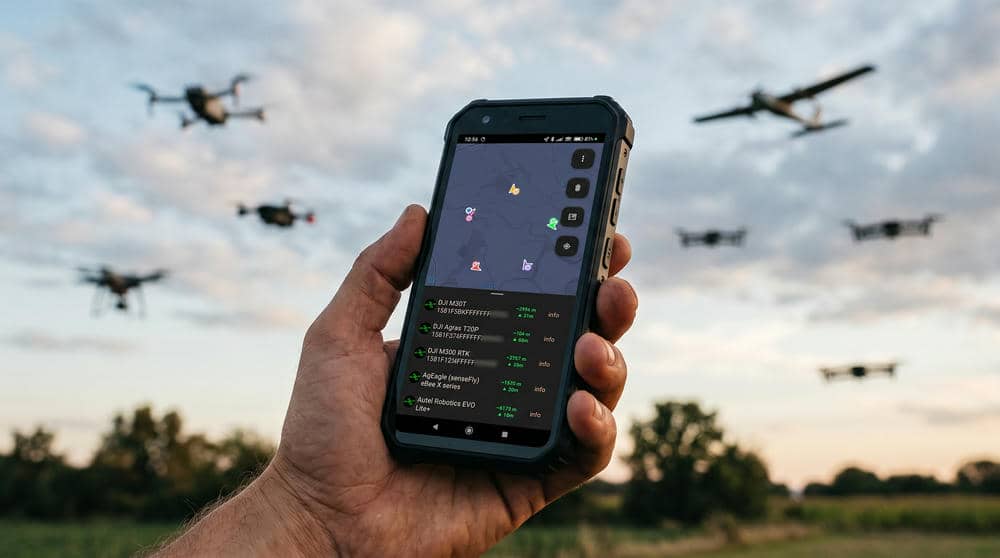
Know your airspace in real time. The D.A.R.S. app receives the Remote ID that drones in the airspace around you broadcast and plots every one on a live map — with alerts, full identification details, flight history and more. Works on its own on a capable phone, or pair a D.A.R.S. receiver over Bluetooth or USB for greater range and dual-band coverage.
Free download · Android 8.0+ · optional one-time PRO upgrade · no native iOS app (iPhone/iPad can view via Home Assistant).
What it does
Everything you need to see nearby drones
The core detection experience is free for everyone. Connect a D.A.R.S. receiver and watch your airspace come alive.
Optional upgrade
Go further with PRO
A single one-time in-app purchase (about €10) unlocks logging, history and forwarding. Everything above stays free — PRO is for power users who want records and integrations.
Requirements
What you need
Android 8.0+
A phone or tablet on Android 8.0 (Oreo) or newer. There is no iPhone / iPad / iOS version.
A receiver — optional
The app can detect on its own using your phone's Bluetooth & WiFi where the device supports it. For reliable range and 2.4 + 5 GHz coverage, pair a Unit C6L or dual-band C5 over Bluetooth LE or USB-C.
Drones broadcasting Remote ID
The app shows drones that broadcast standards-based Remote ID (ASTM F3411 / ASD-STAN). Non-broadcasting aircraft can't be detected by any receiver.
User Guide
D.A.R.S. App — Full Manual
How to install, connect and use every feature of the D.A.R.S. Android app. The core detection experience is free for everyone; a few tools are part of the optional PRO upgrade (marked below).
1Install & permissions
The app is a free download on Google Play. It runs on Android 8.0 (Oreo) or newer. There is no iPhone / iPad / iOS version.
On first launch, grant the permissions it asks for:
- Nearby devices / Bluetooth and Location — required for Bluetooth LE scanning (Android ties BLE scanning to Location). Without them the app can't detect over BLE or connect to a receiver.
- Notifications (Android 13+) — so detection alerts can appear.
2Connect a receiver (or run standalone)
The app shows one unified live feed no matter where the detections come from:
- Standalone — using your phone's own Bluetooth & WiFi radios, where the phone supports it. Range and band coverage depend on the phone.
- D.A.R.S. receiver over Bluetooth LE — power on a Unit C6L or dual-band C5 in DARS mode; the app discovers it and connects automatically over an encrypted link (first connection bonds with "Just Works", then it reconnects on its own). This gives greater range and full 2.4 + 5 GHz coverage.
- D.A.R.S. receiver over USB-C — set the device to USB mode and connect it with a USB-C OTG cable; the app detects it and receives data over the wire.
3The live map
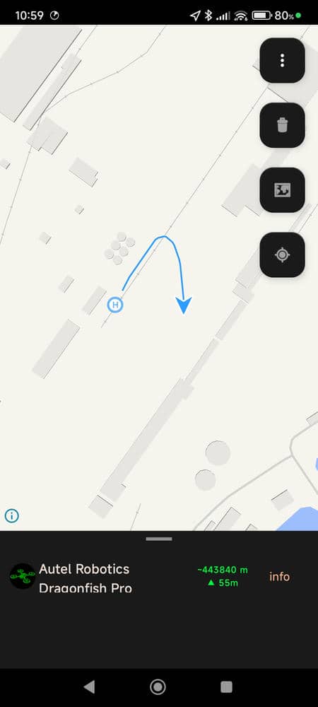
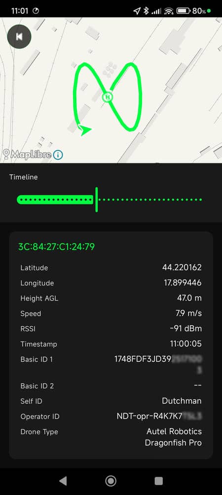
Every detected drone appears as a coloured chevron marker that rotates to its heading, with a track line as it flies and a ring-"H" take-off marker joined to it. Each drone keeps its own colour (the first is D.A.R.S. green).
- Tap any marker to open its full detail view.
- Recenter button re-centres the map on your location.
- Map style button cycles the basemap: Bright, Liberty, Positron, Dark, Fiord and Satellite (high-resolution imagery with street names). The ⓘ button lists the map's data attributions.
- The count badge shows how many drones are currently in range.
4Detection alerts
The moment a new drone enters range, the app raises a heads-up notification — and it keeps working with the screen off and the app in the background, via a foreground scanning service (a persistent notification shows it's running). If your receiver has a buzzer, it can beep too (see Device controls).
5Drone details
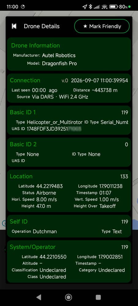
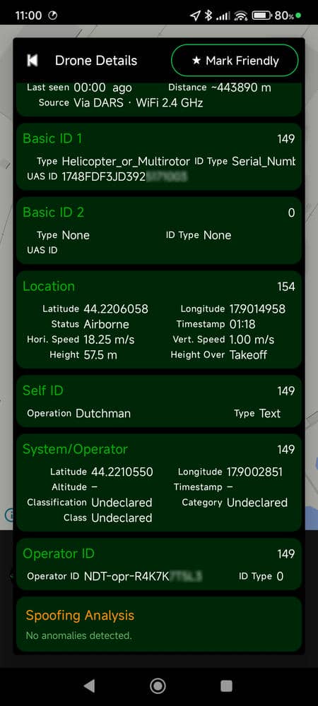
Tapping a drone shows everything it broadcasts over Remote ID:
- Identity — serial / UAS ID, operator ID, self-ID text, UA type.
- Position & motion — GPS position, geodetic & pressure altitude, height above take-off, speed, vertical speed, heading, and the operator / take-off location.
- Signal — RSSI and the detection source / band (e.g. Bluetooth, 2.4 GHz, 5 GHz).
- Make & model — looked up from the FAA UAS Declaration of Compliance database where available (needs an internet connection).
6Above-ground height (AGL) Free
Remote ID only broadcasts height above the drone's take-off point. Over uneven ground that can differ a lot from its real height above the surface below it. AGL estimates that true above-ground height. It is off by default.
Turn it on and download terrain
- Open the side menu → AGL Height and switch on Enable.
- Open Offline terrain, tap the map to drop a pin over your flying area, set a radius, and tap Download — the area is stored on the phone. You can review or delete downloaded areas there.
- The estimated AGL then appears on a drone's detail view whenever it is inside a downloaded area.
Voice call-outs (screen-off)
Under AGL Height → Voice & alerts, enable spoken height announcements that work with the screen off: a call-out each time your drone crosses a height band (e.g. every 20 m), plus a warning at a ceiling you set (default 120 m / 400 ft). Pick which drone to track under My drone, and use Test voice to check/install a text-to-speech voice; each band crossing is also marked with a beep.
7Spoofing detection Free
Optionally flags suspicious or faked Remote ID. When enabled (off by default), a drone's detail view shows a plain-English reason and the marker turns orange if it trips a check: cloned serials, impossible speed, position teleport, frozen or null-island coordinates, or an improbable operator distance.
8Units & settings
Switch the whole app between metric and imperial — metres/feet, m/s or mph, km or miles — and the voice call-outs follow the same choice. Other display options (map style, spoofing toggle, AGL, alerts) live in the side menu and Settings.
9Device controls (External Scanner)
When a D.A.R.S. receiver is connected, Settings → External → External Scanner shows the link status and signal strength and lets you control the device remotely over the encrypted link:
- Onboard buzzer — turn the device's detection beeper on or off.
- Operating mode — switch DARS ↔ USB (the device saves it and reboots). On the C6L, SENSOR mode is also available; LORA mode is switched from the device button.
- Onboard display — on a C5 with the XIAO Expansion Board, toggle its OLED.
- SENSOR / LoRa settings (shown only in SENSOR mode) — publish interval, which fields to publish, LoRa frequency / spreading factor / bandwidth / coding rate / TX power, and creating or joining a DARS mesh channel.
A live "active device settings" readout shows what the device currently has applied, with a Refresh button.
10PRO tools PRO
PRO is an optional upgrade (bundled with a Firmware + PRO licence, or a one-time in-app purchase). It unlocks:
- CSV detection logging — record every detection to a CSV file; choose the log-file location.
- Detection history & replay — browse past detections as a list and replay a flight on the map with play / scrub controls.
- KML export — export tracks to open in Google Earth.
- Friendly drones — mark your own / known serials as friendly so they're highlighted and don't raise alerts.
- Webhook forwarding — POST a JSON payload for each detection to your HTTPS endpoint, with an optional HMAC signature.
- MQTT publishing — publish detections to an MQTT broker on the standard topic hierarchy.
11Share detections — EFB & Home Assistant Free
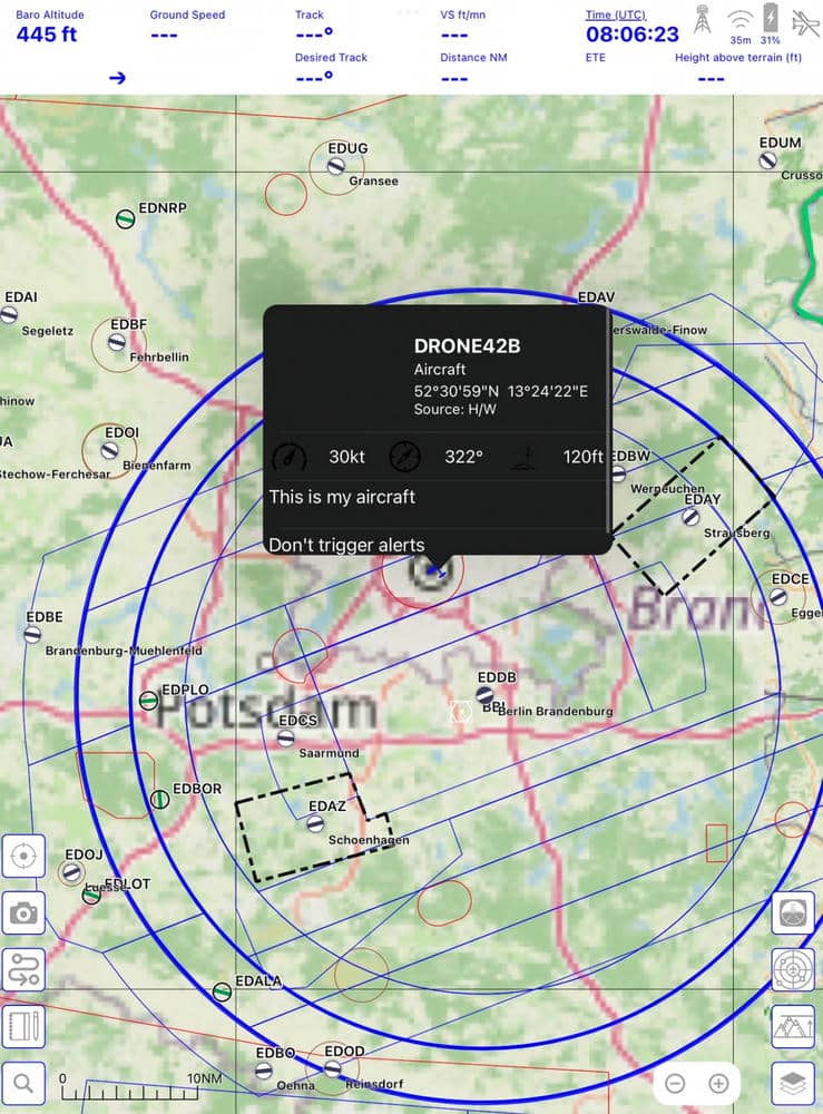
EFB output (GDL-90): under Settings → External, forward detections over Wi-Fi to an Electronic Flight Bag app as GDL-90 traffic — drones appear alongside other traffic, labelled DRONE…. Disabled by default; advisory only.
Home Assistant: a free, open-source integration and map card lets you view detections on a Home Assistant dashboard (a way for iPhone/iPad users to see the feed on a shared screen). See the home page for the integration.
12Enterprise map — DJI Pilot 2 Free
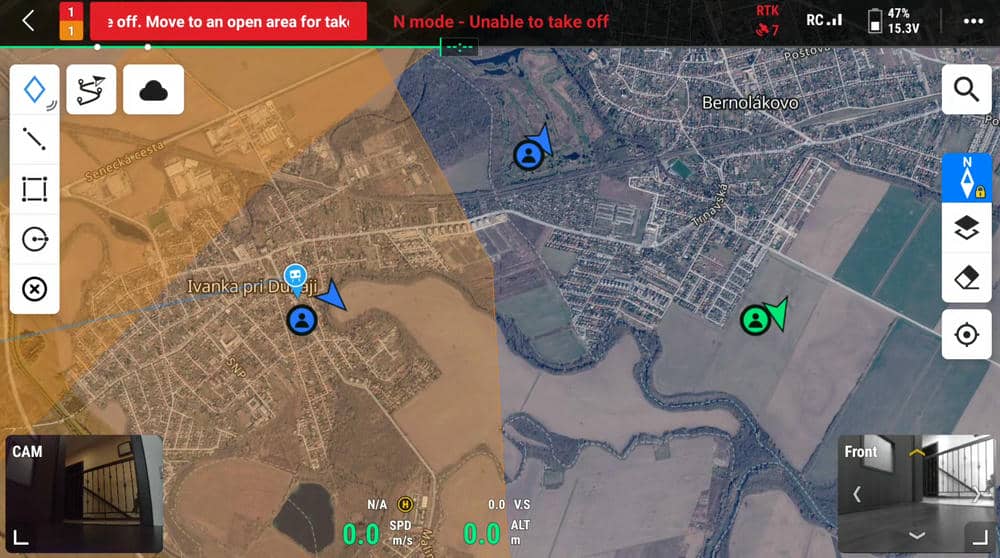
Running on a DJI enterprise remote controller (DJI Pilot 2), the app can place detected drones on the controller's own map, so you see nearby Remote ID traffic next to your own aircraft. Free, and uses the same markers as the in-app maps.
13Widget & background scanning
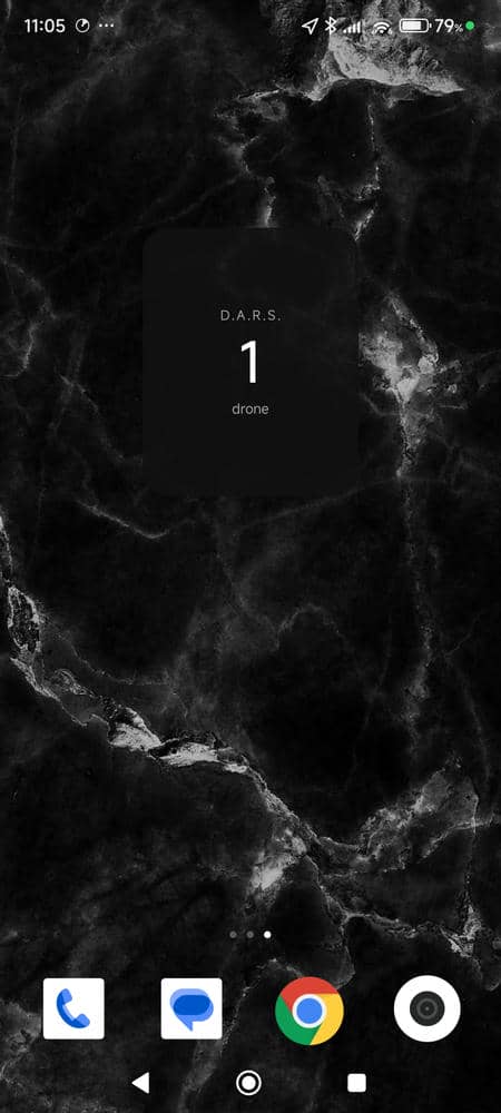
Add the D.A.R.S. home-screen widget for an at-a-glance count of what's around. Background scanning runs as a foreground service, so detection and alerts continue with the screen off — keep the app allowed to run in the background (exempt it from battery optimisation if your phone is aggressive about killing background apps).
14Troubleshooting
- No drones showing — a drone must be actively broadcasting standards-based Remote ID within range; an empty sky simply shows nothing. Check permissions are granted and, if using a receiver, that it's connected (External Scanner shows the link).
- Receiver keeps turning off on a power bank — some power banks cut off at the device's low draw; use one with an always-on / low-current mode, or a wall charger.
- Voice call-outs silent — install a text-to-speech voice (use Test voice), turn media volume up, and make sure a "my drone" is selected.
- Satellite / make-model blank — these need an internet connection on the phone.
Questions
App FAQ
Is the D.A.R.S. app free?
Is there an iPhone / iOS version?
Do I need a D.A.R.S. receiver?
What drones can it detect?
Does it work in the background?
Can I keep records and export them?
Get the D.A.R.S. app
Free on Google Play. Pair it with a D.A.R.S. receiver and see your airspace in real time.
D.A.R.S. is a passive Remote ID receiver for situational awareness — it is not a certified safety, air-traffic, detect-and-avoid or counter-drone system, and must not be used for safety-critical decisions. Remote ID data is broadcast by third parties and may be inaccurate or spoofed. EFB (GDL-90) and DJI Pilot 2 output are advisory only. See the Terms & Conditions.